How the Atmosphere returns solar heat to space and produces our Weather

Site Map
Lesson plan
Glossary
Timeline
Questions & Answers
Central Home Page


(S-1A)   Weather and the Atmosphere

How the atmosphere returns solar heat to space


    An optional extension of section (S-1) "Sunlight and the Earth." A more detailed (but qualitative) discussion of heat flow in the atmosphere and related weather processes, including the roles of buoyancy, convection and humidity. "Global Flows, Global Climate" are separately discussed in section S1-B.

    Index

23a. The Centrifugal Force

  23b. Loop-the-Loop

  24a.The Rotating Earth

24b. Rotating Frames

The Sun

S-1. Sunlight & Earth

S-1A. Weather

S-1B. Global Climate

S-2.Solar Layers

S-3.The Magnetic Sun

S-3A. Interplanetary
        Magnetic Fields

S-4. Colors of Sunlight

  S-4A.Color Expts.

  S-5.Waves & Photons


    Around and around goes the wind,
    and from its circuits returns the wind.

                    Ecclesiastes, ch. 1, v.6

Pressure and Convection

    Let us start with the flow of air. Suppose a "parcel of air" (that's the term you see) is heated near the ground by conduction of heat, the flow of heat due to direct contact with the warm surface. Heat makes it expand, it becomes less dense than the surrounding air and buoyant, and it rises like a hot-air balloon (or like a drop of oil in a bottle of water).

    At the higher levels of the atmosphere, this warm bubble again gives up its heat (to other flows or perhaps to cold space), cools down, and other bubbles coming from below push it to the side, where it descends again. (diagram on the board). Such a circulating flow is called convection.

More generally, convection is any flow which

  1. picks up heat at one place,
  2. drops it at another, and
  3. is driven by this transport of heat.

The important thing to remember when dealing with convective flows, is that the higher one is in the atmosphere, the lower are the pressure and density of the air. What compresses it is the weight of air above it which it must support. On top of Mt. Everest, less air is piled up on top and therefore the pressure is lower.

At ground level, the compressing weight of the atmosphere amounts to about 1 kilogram on each square centimeter. That pressure does not bother our bodies, because the air inside us is at the same pressure, and the fluids of the body (like blood) do not compress easily. For the same reason, fish have no problems with depth--even at a depth of 100 meters, with a pressure 11 times larger (10 kilogram water above each square centimeter, plus the weight of the atmosphere) they feel no discomfort.

    (Divers too can stand such pressure, provided the air they breathe is similarly compressed--except that the mixture must be changed, otherwise they may take in too much oxygen, and too much nitrogen is dissolved in their bloodstream.)

At an altitude of about 5 kilometers, only half the atmosphere is above us, the other half is below, so only the weight of half the atmosphere must be supported, and the pressure is reduced to one half.

By "Boyle's law" (named for Robert Boyle, 1627-91), the density is also reduced to one half (ignoring any variation in temperature). Rising an additional 5 kilometers, the pressure again falls by half, to 1/4 of what it was on the ground, and at 15 kilometers, it is halved again to about 1/8. All this is approximate and depends on temperature, but the trend should be clear.

The cabin of a jetliner flying at 10 km must be sealed and pressurized, because passengers breathing air at 1/4 the sea-level density would be starved for oxygen and might lose consciousness. On the very rare occasions when a jetliner loses its pressure, masks connected to oxygen canisters drop down automatically, allowing the passengers to breathe normally while the pilot quickly descends to a lower altitude.


The Higher We Go, the Cooler it Gets--Why??

When the atmosphere is stable, the higher we go, the cooler the air is.

Air is warmest near the ground, which absorbs receives heat from sunlight. It is coldest above the level where jetliners fly, at 10-15 kilometers, the region from where it radiates most of its heat into space. That is why mountaintops are cold and the highest mountains have snow on their tops.

    (Still higher layers may get quite hot again, by absorbing UV and "extreme UV," but they have little effect on what goes on below them).

How exactly does this happen?

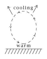
Suppose some "parcel of air" (dry air, for now--humidity is an additional factor, considered later) is heated by the ground and rises. Higher up the pressure is lower, so the air expands: but expansion cools it.

Similarly, if for some reason the parcel is blown down, is is compressed again and heated by the compression. Such up-and-down motions happen all the time, and the net result is that when conditions are stable, the temperature drops at a steady rate as we go higher.

The motion of the rising parcel of air depends on its surroundings. It always cools by expansion--but is it still warmer than the still air around it? If it is, it continues to rise; if not, it stops. As will be seen, this is where the humidity of air has an important effect.

    [ On an ordinary day, direct heating by the ground only carries the air a few hundred meters, perhaps a kilometer, creating above the ground a "boundary layer" with many small convective flows. Large scale motions like thunderstorms usually occur higher up (see below).]

Water Vapor

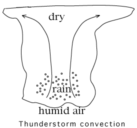
   Instead of heating the Earth, sunlight can evaporate water from it--especially from the oceans, which cover most of the Earth's surface. Humid air may be viewed as containing additional energy, invested by the Sun when its heat evaporated the water. While heat drives convection, humidity may amplify it.

   Hot humid air is what drives thunderstorms, and a warm ocean surface is also the traditional birthplace of violent tropical storms, known as hurricanes in America and typhoons in Asia.

We look at two examples of humidity in action.

  1. In a thunderstorm, hot humid air rises, as in ordinary convection. As it rises to regions of lower pressure, it cools by expanding. However, cold air cannot hold as much humidity as warm air, and the extra water is therefore squeezed out. In moderate convection it forms clouds (as in the second example below), but in a vigorous thunderstorm, there is too much of it and it turns into rain.

       Giving up water heats the air, or rather, slows down its cooling, because the heat invested by the Sun in evaporating the water is now passed back to the air. As a result, the rising air is still warmer than the air layers around it, and it continues to rise vigorously. It squeezes out still more rain and forms the tall thunderstorm clouds, which pilots know well to avoid.

          (In very vigorous thunderstorms, the "updrafts" of rising air may rise so quickly that they blow raindrops into the higher and colder sections of the cloud, where they freeze, producing hail. Some hailstones are picked up again and again, adding layers of ice on each upwards journey. That is how unusually big hailstones can form.)

    The drawing shown here is obviously two-dimensional, and does not tell what the cross section of the thunderstorm is in a direction perpendicular to the drawing. That can vary: some thunderstorms are isolated and their cross section in the 3rd dimension resembles the one drawn. In other case, the thunderstorm activity extends in the 3rd dimension for a long distance, creating a squall line. If on a map of radar reflections you see a squall line advancing towards you, it is unlikely the thunderstorms will miss you.
  1.    On a hot clear day, many fluffy small clouds may form. A light plane flies across the land, and every time it comes under a cloud, the pilot feels that it is bodily lifted. What is happening?

       --Here is the reason. The heating of the ground by the Sun has created many small convection currents rising upwards. Their air contains humidity, not enough for a serious thunderstorm, but enough to produce small clouds when droplets of water condense as the rising air cools.

        The small clouds mark the top of the "boundary layer" near the ground, with many small circulating flows. Each cloud sits on top of a rising convection current, which lifts the airplane as it flies across it. Since "what goes up must come down" the pilot can also expect downdrafts between the clouds, where the air goes down again, as part of the circulating convection. Such up-and-down motions may make passengers on low-flying airplanes quite airsick!


Tidbit:

   Who first wrote "Everybody talks about the weather, but nobody does anything about it"? Most would claim it was Mark Twain (just type the first 5 words into a search engine and see!), but it ain't necessarily so. It reads like Twain's style, but actually the words first appeared in an editorial in the Hartford (Conn.) Courant on 24 August 1897, written by Charles Dudley Warner.

    Warner was a good friend of Twain, who himself had lived in Hartford for many years (he left before 1897). He was a newspaperman in Hartford and the two had collaborated on an 1873 book "The Gilded Age." Warner is also remembered for other quotes, e.g. "Politics make strange bedfellows."

Concerning the quote, see on the web
        http://www.m-w.com/wftw/99aug/082499.htm.
and more about Charles Dudley Warner (and Twain) at
        http://courant.ctnow.com/projects/twain/warner.htm


Questions from Users:   "Doesn't heat rise?"
                            ***     Sudden decompression, 5 miles up
                               ***     What does "lapse rate" mean?

Optional Next Stop: (S-1B) Global Climate, Global Wind Flow
Next Regular Stop:   (S-2) Our View of the Sun

            Timeline                     Glossary                     Back to the Master List

Author and Curator:   Dr. David P. Stern
     Mail to Dr.Stern:   stargaze("at" symbol)phy6.org .

Last updated: 9-22-2004
Re-formatterd 26 March 2006